![]()
Christina Knopf is an Associate Professor of Communication at the State University of New York at Potsdam, whose research addresses the rhetoric of military experience and civil-military dialectics.

Contact: [email protected]
Sense-Making and Map-Making: War Letters as Personal Geographies
by Christina M. Knopf
published November 2014
1. Introduction
In a letter home from Bataan during World War II, Sgt. J.M. Smith wrote, “you would never know what it could be like unless you were here [emphasis added]” (in Carroll, War Letters 193). Place and displacement are significant to the experience of war, with war’s activities shaped by terrain and travel. Research on war letters and diaries suggests that epistolic narratives may reveal how people (re)identify with particular communities during times of war (Gill). This project expands on that idea, proposing that war letters can act as spatial artifacts that help to translate and negotiate the disorienting experience of war, blending the situated knowledge of narrative with the abstract/detached view of military geographical training (see Hegglund on work between narrative and cartography). Like Laurene Vaughan’s consideration of walking as affective understanding of place, this article also considers multiple means of recording spatial experiences, with letters as one medium for “personal geographies” of military campaigns (Cartwright). Structured in three parts, this article will briefly review Herman’s idea of “spatial reference” in narrative, particularly in epistolary form, and explain the research method used in this project; introduce military geographies and demonstrate how various spatial references function in war letters; and, lastly, illustrate the value of war letters as spatial artifacts and subjective cartography.
2. Place and/in Narrative
Place and narrative are reciprocal productions (Tuan; also Caquard; Entrikin; Herman). Orientation elements in narratives can connect narrators and audiences (Herman, Spatial Reference), while narrative elements in cartography help to express human experience and “lived space” on a map (Pearce; Tuan). Narrative itself can be a “spatially symbolic act” (Tally), and (re)orientation can be managed and achieved in/through narratives. In a study of border-crossing accounts of undocumented Mexican immigrants, Anna De Fina noted that people who live disorienting experiences articulate orientation for their audiences (also see Monga on geographic displacement). David Herman (Spatial Reference) usefully applied the concept of spatialization to narrative inquiry by outlining six key ideas, or features, of “spatial reference” applicable to narrative and epistolic analysis: the deictic shift in which the narrator prompts the audience to relocate from the site of the communicative interaction to the space-time location of the narrative; a distinction between figure and ground; notions of regions, landmarks, and paths; differentiation between topological and projective locations; functions of motion verbs; and distinguishing between the rich noun-based system of what and the limited adverb and preposition-based system of where. Herman uses “spatial reference” for these features, so that phrase will be used here. These features, however, verbally code not only space but also place, which Gieryn defines as having geographic location, material form, and imbued value. Epistolic narratives in particular use deliberate forms of deixis to refer to the writer, intended reader(s), time, and space, invoking the “two worlds” of sender and receiver and managing the spatio-temporal distance between them (Barton and Hall 6). An analysis, using generative criticism premised on Herman’s delineation of spatial reference (for other examples of generative criticism, see Rowland & Rademacher; Terrill), of more than 250 U.S. war letters from the American Revolution to Operations Enduring and Iraqi Freedom, published in five collected anthologies, reveals that spatial awareness is a prominent feature of accounts of warriors to those at home—with 120 of the letters using spatial reference in significant ways.
3. Military Geographies
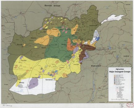
Spatial and locational awareness in accounts from/of war are not surprising. Geographic understanding and awareness are key factors in military training and activity. Rachel Woodward argues that “militarism and military activities create spaces, places, environments and landscapes with references to a distinct moral order” (3). Military geographies are about the material and discursive control of land, involving economics, information, social order, space, environments, and landscapes, with focus on the influence of physical and cultural environments on local to global policies and operations. The physical factors include spatial relationships, topography, geology, vegetation, bodies of water, climate/weather, daylight/darkness, and gravity/magnetism. Strategists see these as mountains, valleys, plateaus, and plains, classified according to surface configurations, climactic labels, elevations, temperature gradients, or spheres. Frontline soldiers see them as rocks, gullies, river banks, dirt, and mud, described according to comfort and convenience. Military personnel are, therefore, trained in the art of fieldcraft—survival based on continuous analysis in regards to critical or key terrain, obstacles, cover and concealment, observation and fields of fire, and avenues of approach. Cultural factors of military geography include race, ethnicity, religions, population, social structures, language, industries, transportation, telecommunication, and military installations (Collins; Starbuck; Woodward, Military Geographies). Diverse cultural geography is represented in Figure 1.
4. Spatial Reference in War Letters
A closer look at how spatial reference is used in war letters demonstrates its function not only in recounting the writers’ activities, but also in helping the writers to reorient themselves in the disorienting experience of war. Additionally, spatial reference may help readers to better understand the places and actions of war. Cartography’s usefulness in reporting war to the general public has already been recognized by the news media (Vujakovic; Cartwright). Through verbal representations of the location, form, and meaning of places writers encountered and ones they remembered, and of what they did there and why, the letters serve as interpersonal maps of experience. As William Cartwright argues, “Personal geographies can be used to give an insight into the human stories of traveling to battle, the preliminary movements, the battle itself and combatant’s reflections on what has happened” (38). This project further suggests the fruitfulness of war letters in narrative cartography (Caquard), along the lines of Robert MacFarlane’s “story maps” which express personal experiences, and promote deeper understandings, of place. Furthermore, it picks up a thread of Woodward’s argument (From Military Geography) regarding attention to representation and human geography concerned with military geospatial activities.
Predictably, given the characteristics of epistolary, deictic shifts are a key element of spatial references in war letters. The sharing of daily life with another across a distance is at the heart of letter writing. In the words of Pfc. Donald Luedtke, writing to his mother during the Korean War, “Well, I suppose you wonder where I am, and where I have been” (in Carroll, War Letters 323). In fact, letters might feature multiple deictic shifts, leading the reader either around a particular event or through a series of events. Many warriors explain battles, particularly ones in which they were wounded or lost a buddy or family member, with a deictic shift—prompting both reader and writer to the location of their loss. Another kind of deictic shift is found in letter “flashbacks,” where a writer recounts activity that occurred many months earlier, particularly at the end of a war or after deployment. In the following example, Pfc. Edgar Shephard felt compelled to write to the parents of a dead comrade who saved his life in WWII: “It all happened one year ago tonight. We had just returned from the raid of Toranboca and set up positions on a barred ridge (later called Bloody Ridge)” (in Carroll, War Letters 197). Shephard’s tale continues with attention to how the terrain influenced the actions that led to his wounds and his friend’s demise.
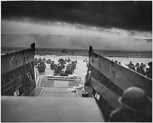
Topological and projective locations, often in conjunction with notions of figure and ground, are common in these accounts, frequently overlapping with elements of fieldcraft in military geography. Projective locations are frequently found in describing weaponry fire in relation to the location of the writer. Capt. David F. Embree captured such description, in a darkly poetic missive to his sister about hearing the “singing of the bullet” on its deadly course: “The ball came obliquely from the left and front and passed several feet in front of me. It seemed that I could hear it singing almost from the time it left its bed in the rebel’s gun, and as it swiftly came I knew where it was going, by the sound” (in Carroll, War Letters 93). Warriors note the climate, the terrain, and the relative position of friendly and antagonistic forces as a means of explaining what happened and, particularly, what actions they did or did not take. In the words of Lt. David Ker in WWI, “The rugged and heavily wooded character of the country makes the task which we face extremely difficult, and the losses are almost certain to be considerable” (in Carroll, War Letters 148). One of the most explicit connections of topological and projective locations with fieldcraft came out of D-Day. Writing to his parents, S.Sgt. Eugene Lawton described the events of the invasion, explaining directly how his military training was used to navigate the waters of the Channel and the beach of Normandy, stating that his training had been used twice in the landing alone—“Never run in water as you can be carried along by waves much easier,” and “Never hit the ground in the open when under fire” (in Carroll, War Letters 236). This landing is seen in Figure 2. Many WWII-era letters similarly discussed the terrain in relation to defense—such as whether there was protective cover and how easily the ground gave way for digging fox holes.
Motion is a significant component of described actions. Interpretations of motion depend on the noun and adverb systems inherent in location and form. Confederate Capt. Francisco Rice captured motion in warfare writing to his wife in the American Civil War: “The scenes through which we have passed, and the part we have enacted in the great Tragidy [sic] will be properly recorded in the history of this revolution” (in Carroll, War Letters 83). Ideas of motion are frequently rolled into the nature of military operations; a military maneuver, by definition, requires movement. In the words of 1st Lt. Sidney Diamond during WWII, “A soldier always ‘departs’ He never ‘arrives’ [...] You never get where you’re going” (in Carroll, War Letters 292). Inherent in these movements are notions of territory that must be crossed in order to be conquered. As 2nd Lt. Charles W. Larned wrote in the US-Indian Wars, General Custer received orders to “push on with the whole of the available cavalry force, make forced night marches, and overtake the village, if possible” (in Lowenherz 44). Movement is also explicit in the potential for and reality of death, wherein warriors depart the world, arrive at the end of their journey, and exist “somewhere between here…death and home” (in Carroll, Operation Homecoming 277).
Regions, landmarks, and paths help writers to reaffirm identity and reinforce bonds, and they provide concrete details for stories that are otherwise difficult to tell. Expressions of identity are frequently connected with regions, focusing most often on differences, or perceived differences, between “us” and “them,” though occasionally, a warrior notes human similarities despite geographical differences. Regional differences or similarities are sometimes wrapped in justifications, and condemnations for the cause of war—doing good things for deserving peoples, fighting against barbaric peoples, or being in a land not worth saving.
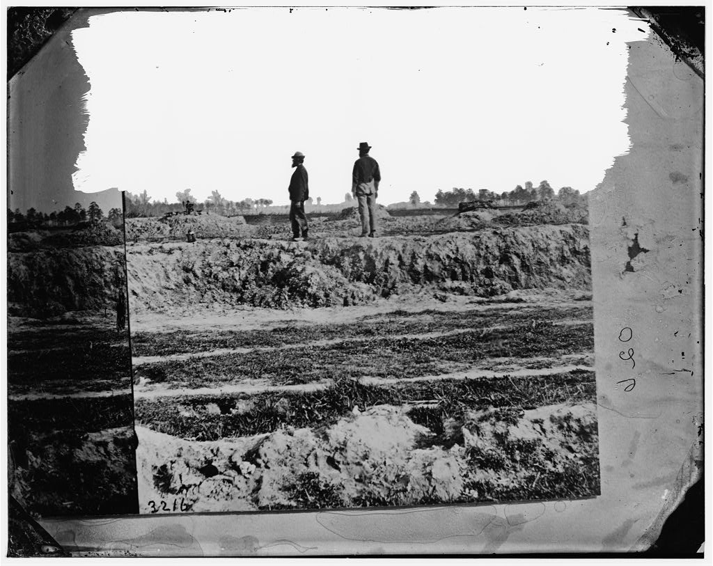
References to landmarks are one means through which the warrior writers reinforce bonds with loved ones at home by referring to particular locations they both know to explain an event, engage in wistful nostalgia, or voice thoughts of the future. For example, Sgt. Thomas Bowen wrote to his mother of Petersburg in the Civil War, telling her that the Rebel and Union lines “are at this point not farther apart than from your house to James Fosters” (in Carroll, War Letters 97). Figure 3 vividly captures the placement of the lines. Likewise, 2nd Lt. Daniel Harvey wrote to his mother from the Mexican War: “When I first saw the Rio Grande at its mouth I thought it little more than a muddy little creek, scarcely larger than Alison’s Creek when swollen” (in Lowenherz 116). Such references to the home-front as analogous to the warzone may offer comfort to both the warrior and loved ones by demonstrating shared similarities. “Home” is a frequently mentioned landmark, often the central feature of expressed hopes (or fears) for the future and wishes for the present. The full extent of the emotion wound through the idea of home is found in Petty Officer 2C Edwin Garcia-Lopez’s letter from Iraq, who missed the home built of sweat and sacrifice, kneeling in the damp ground of his vegetable garden, watching the sprouts break through to the sun to later “bring to our mouths a little piece of heaven from our blessed earth” (in Carroll, Operation Homecoming 229). Distances and/or landmarks may also offer reassurance of the warrior’s safety. Chaplain Ray W. Stubbe told his parents from Vietnam, “My hooch’s well-built, sturdy” (in Carroll, War Letters 407). From Operation Desert Storm, S. Sgt. Frank Evans told his parents, “I think I’ve told you before that any chance of Iraq’s weapons reaching us here is extremely low” (in Carroll, War Letters 449).
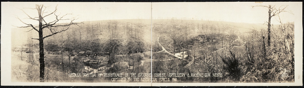
Paths are sometimes used metaphorically to express similar sentiments of nostalgia, as in the letter from 2nd Lt. Francis M. Tracy to his wife in the first World War, “I go back and retravel again the entire road that we have known together [...] If I had to go over the same road with you again, I am quite sure the way would be easier for you” (in Carroll, War Letters 153).More often, paths are referenced literally, intrinsic to the portrayal of motion, as painstakingly detailed by Elmer Sutyers when recounting the Meuse-Argonne Offensive—“pressing through a thicket,” going “hand to hand” through the woods, “storming” Grendpré with “short five or ten yard dashes,” and “sneaking about the ruins” and “up a steep hill, thickly wooded” (in Carroll, War Letters 163, 165). The Argonne terrain is pictured in Figure 4.
5. War Letters as Spatial Artifacts, Personal Geographies, & Cartographic Data
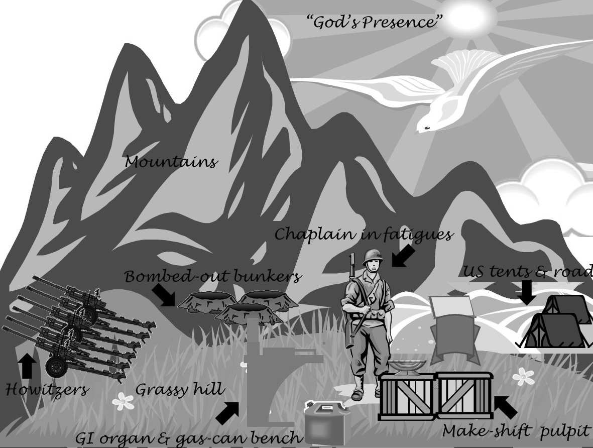
Writing from the Korean conflict, Capt. Molton A. Shuler meticulously described to his wife the field church he attended:
Picture a grassy hillside surrounded by mountains. And a rugged looking […] chaplain dressed in fatigues standing by a Government Issue folding podium with a red velvet cover and brass candelabra minus candles, all placed on a couple of ammo boxes.
Then just left of the “pulpit” as you face it you find a battered, 30-odd key, olive drab organ, a GI pianist seated on a 5 gallon gasoline can. And in the background you find blasted Chinese bunkers and old gun emplacements. Then if you look way up to your left you’ll see a battery of 6 105 howitzers [...] To the right and up on the valley are bunkers of our company, a couple of tents from which winds a road (one way) behind our “church.”
[. . .]
And God is in this “chapel”—so near you can almost reach out and touch Him. (Carroll, War Letters 356-7)
Shuler’s account is so detailed that a crude visual representation of his “church” can be created from it. Figure 5 shows such an effort, depicting the geography and corresponding emotion suggested. This passage and the rudimentary map it inspired highlights and reinforces the idea that war letters can serve as interpersonal maps of the human experience of place and thereby guide the writers-as-cartographers and readers-as-navigators to heightened understanding of other places and experiences.
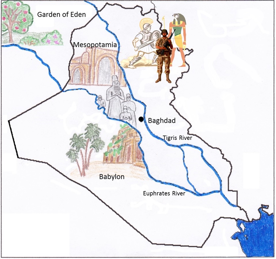
More detailed maps representing training, traveling, billeting, or fighting could also be constructed from war letters, much as Margaret Wickens Pearce mapped eighteenth-century voyageur geography in the Upper Great Lakes. War letters, therefore, not only may serve as personal narratives and spatial artifacts qua letters, but have the potential to be used as/mined for cartographic data for the creation of “lived space” war maps, particularly with growing digital grid map technologies (see Caquard). For example, Figure 6 maps the impressionistic epistolic account of Lt. Col. Chris Cohoes’ flight over Iraq in 2004, using a traditional grid map as its base. Though room here prohibits quoting the lengthy letter itself, Cohoes told his sons about the landmarks of Iraq and the region’s ancient and fabled history, reflecting on his own place in that history (in Carroll, Operation Homecoming 233-4).
6. Conclusion
Robert T. Tally, Jr. writes, “If the writer is a mapmaker, the critic is a map-reader, who […] also creates new maps in the process." While Tally discusses literature, the same may be said of the letter writer and the letter reader. In the transformational, disorienting, life-and-death experience of war, this navigational process is particularly valuable. Geospatial information and action is intimately connected with warfare; cartographic representation not only assists the development of military strategy but also provides a means for explaining military threats and activities to a wider audience. (Re)orientation to the war-changed landscape of life can be achieved, for both warrior and civilian, through the spatial narrative structure and spatial contexts.
Works Cited
Barton, David and Nigel Hall. Introduction. Letter Writing as a Social Practice. Eds. David Barton and Nigel Hall.Philadelphia: John Benjamins P, 2000. 1-14. Print.
Caquard, Sébastien. “Cartography I: Mapping Narrative Cartography.” Progress in Human Geography 37.1 (2011): 135-44. Print.
Carroll, Andrew, ed. Operation Homecoming. Chicago: U of Chicago P, 2006. Print.
---, ed. War Letters. New York: Scribner, 2001. Print.
Cartwright, William. “An Investigation of Maps and Cartographic Artefacts of the Gallipoli Campaign of 1915: Military, Commercial and Personal.” Geospatial Visualisation. Eds. Antoni Moore & Igor Drecki. New York: Springer, 2013. 19-40. Print.
Collins, John M. Military Geography for Professionals and the Public. Washington, DC: Brassey’s, 1998. Kindle file.
De Fina, Anna. “Crossing Borders: Time, Space, and Disorientation in Narrative.” Narrative Inquiry 13.2 (2003): 367-91. Print.
Entrikin, J. Nicholas. The Betweenness of Place: Towards a Geography of Modernity. Baltimore: The Johns Hopkins UP, 1991. Print.
Gieryn, Thomas F. “A Space for Place in Sociology.” Annual Review of Sociology 26 (2000): 463-96. Print.
Gill, D.C. How We Are Changed by War: A Study of Letters and Diaries from Colonial Conflicts to Operation Iraqi Freedom. New York: Routledge, 2010. Print.
Hegglund, Jon. “Ulysses and the Rhetoric of Cartography.” Twentieth-Century Literature 49.2 (2003): 164-92. Web. 1 Nov. 2013.
Herman, David. “Spatial Reference in Narrative Domains.” Text 21.4 (2001): 515-41. Print.
Herman, David. Story Logic. Lincoln: U of Nebraska P, 2002.Print.
Lowenherz, David H., ed. The 50 Greatest Letters from America’s Wars. New York: Crown P, 2002. Print.
MacFarlane, Robert. The Wild Places. New York:Penguin, 2008. Kindle file.
Monga, Luigi. “Translating the Journey: A Literary Perspective on Truth in Cartography.” Annali d’Italianistica 21(2003). Web. 1 Nov. 2013.
Pearce, Margaret Wickens. “Framing the Days: Place and Narrative in Cartography.” Cartography and Geographic Information Science 35.1(2008): 17-32. Print.
Rowland, Robert C. and Thea Rademacher. “The Passive Style of Rhetorical Crisis Management: A Case Study of the Superfund Controversy.” Communication Studies 41.4 (1990): 327-42. Print.
Starbuck, J.A. “Military Needs for Personal Navigation.” Journal of Navigation 48.01 (1995): 77-80. Print.
Terrill, Robert E. “Put on a Happy Face: Batman as Schizophrenic Savior.” Quarterly Journal of Speech 79.3 (1993) 319-35. Print.
Tuan, Yi-Fu. “Language and the Making of Place: A Narrative-Descriptive Approach.” Annals of the Association of American Geographers 81.4 (1991): 684-96. Print.
Vaughan, Laurene. “Walking the Line: Affectively Understanding and Communicating the Complexity of Place.” The Cartographic Journal 46.4 (2009): 316-22. Print.
Vujakovic, Peter. “Mapping the War Zone: Cartography, Geopolitics and Security Discourse in the UK Press.” Journalism Studies 3.2 (2002): 187-202. Print.
Woodward, Rachel. “From Military Geography to Militarism’s Geographies: Disciplinary Engagements with the Geographies of Militarism and Military Activities.” Progress in Human Geography 29.6 (2005): 718-40. Print.
Woodward, Rachel. Military Geographies. Malden, MA: Blackwell, 2004. Print.
Figures
1. US Central Intelligence Agency. "Afghanistan Major Insurgent Groups." 1985. Library of Congress Geography and Map Division, Washington, D.C. Web. 3 Apr. 2013. JPEG.
2. "Into the Jaws of Death—U.S. Troops Wading through Water and Nazi Gunfire." 1944. Franklin D. Roosevelt Library, Hyde Park, NY. Web. 3 April 2013. GIF.
3. Petersburg, Virginia. "View Showing How Close Picket Lines to Each Other." 1865. Library of Congress Prints and Photographs Division, Washington, D.C. Web. 3 April 2013. JPEG.
4. Schultz Group Photographers. "German Position of Resistance in the Argonne Forest, Artillery & Machine Gun Nests, Captured by the American Forces, 1918." 1918. Library of Congress Prints and Photographs Division, Washington, D.C. Web. 3 Apr. 2013. JPEG.
5. Knopf, Christina M. “Visual representation of Shuler’s field chapel.” 3 Nov. 2013. MS Clip Art file. JPEG.
6. Knopf, Christina M. “Grid/story map of Cohoes’ impression of Iraq.” 3 Nov. 2013. MS Clip Art file. JPEG.